Caballo, New Mexico
Census-designated place in New Mexico, United States
|
Caballo, New Mexico
|
|
|---|---|
|
Census-designated place
|
|


Caballo, New Mexico
|
|
| Coordinates: 32°58′32″N 107°18′28″W / 32.97556°N 107.30778°W / 32.97556; -107.30778 | |
| Country | United States |
| State | New Mexico |
| County | Sierra |
| Area | |
| • Total | 0.98 sq mi (2.54 km 2 ) |
| • Land | 0.98 sq mi (2.54 km 2 ) |
| • Water | 0.00 sq mi (0.00 km 2 ) |
|
Elevation
|
4,252 ft (1,296 m) |
| Population | |
| • Total | 77 |
| • Density | 78.49/sq mi (30.32/km 2 ) |
| Time zone | UTC-7 ( Mountain (MST) ) |
| • Summer ( DST ) | UTC-6 (MDT) |
| ZIP code |
87931
|
| Area code | 575 |
| GNIS feature ID | 898738 [3] |
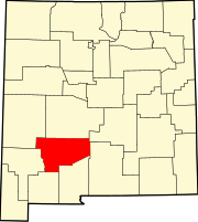
Caballo is a census-designated place in Sierra County , New Mexico , United States. Its population was 112 as of the 2010 census . [4] Caballo has a post office with ZIP code 87931. [5] [6] The community is located along New Mexico State Road 187 , north and south of Exit 63 on Interstate 25 .
Caballo was founded in 1908, when John Gordon and his extended family homesteaded here. It was named after the mountains to the east. A post office was established in 1916. In 1938, the Caballo Dam was constructed, creating a lake which forced residents to re-establish the community to the west. [7] The lake is host to Caballo Lake State Park .
Geography
Caballo is located at 32°58′50″N 107°18′27″W / 32.980625°N 107.307469°W / 32.980625; -107.307469 . According to the U.S. Census Bureau , the CDP has an area of 0.979 square miles (2.54 km 2 ) , all land. [4] The area stretches for over five miles and includes an active fire department and many businesses, and residences. It borders Caballo Lake State Park .
Demographics
| Census | Pop. | Note | %± |
|---|---|---|---|
| 2020 | 77 | — | |
| U.S. Decennial Census [8] [2] |
Education
Truth or Consequences Municipal Schools is the school district for the entire county. [9] Truth or Consequences Middle School and Hot Springs High School , both in Truth or Consequences, are the district's secondary schools.
References
- ↑ "ArcGIS REST Services Directory" . United States Census Bureau . Retrieved October 12, 2022 .
- 1 2 "Census Population API" . United States Census Bureau . Retrieved October 12, 2022 .
- ↑ "Caballo" . Geographic Names Information System . United States Geological Survey , United States Department of the Interior .
- 1 2 "2010 Census Gazetteer Files - Places: New Mexico" . U.S. Census Bureau . Archived from the original on July 14, 2014 . Retrieved August 21, 2014 .
- ↑ "Postmaster Finder - Post Offices by ZIP Code" . United States Postal Service . Retrieved August 21, 2014 .
- ↑ United States Postal Service. "USPS - Look Up a ZIP Code" . Retrieved August 21, 2014 .
- ↑ Julyan, Robert (1996). The Place Names of New Mexico . University of New Mexico Press. p. 54. ISBN 0826316891 .
- ↑ "Census of Population and Housing" . Census.gov . Retrieved June 4, 2016 .
- ↑ "2020 CENSUS - SCHOOL DISTRICT REFERENCE MAP: Sierra County, NM" (PDF) . U.S. Census Bureau . Retrieved July 12, 2022 . - Text list
External links
|
Municipalities and communities of
Sierra County, New Mexico
,
United States
|
||
|---|---|---|
| Cities |
|
|
| Villages | ||
| CDPs | ||
|
Other
communities |
||
| Ghost towns | ||

|
This New Mexico state location article is a stub . You can help Wikipedia by expanding it . |